
Martic Township Park
- Aug 24, 2023
- 4 min read
1092 Marticville Rd. | Martic Township
Martic Township Park is a bit of a hidden gem. The parking lot is rarely full, compared to other hiking spots in the area. The trails throughout the park allow you to experience the beauty that Martic Township has to offer. It also has a lot of steep hills, if your looking for a good workout. Several of the trails run along a stream with tranquil cascades and clear pools. There are also lots of mossy rocks. I love mossy rocks!
In the 90's this land was to be sold to a developer who planned to turn it into a golf course. Thank goodness environmentally minded citizens objected and the land was sold to Martic Township.
Be sure to grab a map, as not all of the trails are clearly defined or marked. Hunting is permitted in this park, so remember to wear orange during hunting season.
Distance: 4.3 miles of trails
Terrain: dirt | water | rocks | gravel | wooded
Difficulty: medium to medium well
Activities: hiking | trail running | creek stomping | leashed dogs
Parking: mid-size parking lot
Restrooms: no
Website: martictownship.com
Yellow Trail | .85 miles
Medium/ Med Rare | 20-40 min
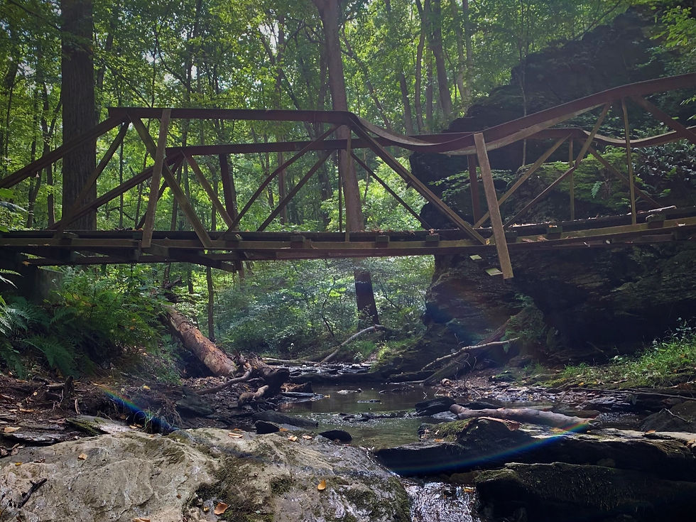
This trail starts at the parking lot and is the only trail into the park. There are 2 points to start in the parking lot, but they meet up after the very steep hike up the hill. Once you get to the top of the hill it looks like the trail goes 2 different directions, it does not. Go left, to the right is actually the red trail. It is just mismarked. The yellow trail connects to the red, pink and blue trails. This is a very picturesque trail that runs along a cascading stream. There is an old bridge to cross and lots of mossy rocks and trees. After the yellow trail turns away from the stream it goes up a steep hill.
Red Trail | .42 miles
Medium Rare | 10-20 min
Like I stated above, the beginning of the red trail is mismarked. It begins at the top of the hill where it looks like the yellow trail splits in 2 directions. Go Right to pick up the red trail. The red trail only connects with the yellow trail in that one spot, so you will have to backtrack when you reach the end of the park. This is a lovely trail through the woods. It is mostly level and only goes downhill when you get to the end of the property. At the end, the woods opens up to a grassy field. Be sure to look for the stone wall to the left before you reach the field.
Blue Trail | 2 miles
Medium\Med Well | 1hr -1½ hrs
This is the longest trail in the park and it takes you to the edges of the property. It connects with the yellow trail and at 3 different points on the green trail.
The portion of The Blue Trail that is below the Yellow Trail will take you ½ mile down to Marticville Rd. There is a point in the trail that appears to go left, the trail is actually straight ahead, through a parkour style gauntlet of downed trees. If you have adventuresome kids, this section of the trail is for you. After the trees, the trail goes downhill with mossy rocks built up on either side. It really is pretty. You will need to backtrack to exit the park.
The portion of the Blue Trail that starts in the middle of the green trail is a beautiful section along the stream. This this trail is off to the right just after you start up the Green Trail. After you climb over a large double fallen tree the trial will turn and head uphill, but if you follow the stream for a little longer, you will see a mini waterfall. You can hear it as you approach.
At 2 different points the blue trail crosses over a powerline right of way. This takes you to the upper portion of the park. The trail is wide and is covered with gravel and rocks. It's not a particularly scenic section of the trail, but it is good if you're looking to get more steps in.
Green Trail | .85 miles
Medium\Med Well | 20-40 min
This trail probably gets the least amount of traffic. The markers can also be hard to locate. The trail is a U shape and goes up and down a very steep hill. The section that first connects to the Blue Trail is a bit overgrown and at times it's difficult to determine where the trail goes. If you pick up this portion of the trail from the Pink Trail it can be a bit difficult to find. It is at the crest of a small hill on the trail and goes straight up the embankment. The second turn uphill is easier to find. It is sort of a wash filled with rocks. This portion will take you to the utility clearing where you can then connect to the Blue Trail.
Pink/Un-blazed Trail | 2 miles
Rare | 5-10 min
This trail is used as a connector for the yellow and green trails. When the yellow trail crosses the stream and heads uphill, go right, continuing along the stream to pickup the pink trail. The color of the trail marker varies. Sometimes it's pink, sometimes it's more orange.
Directions:
From Lancaster city go south on N. Prince St/PA 222 S
Right onto PA 324 S/New Danville Pike
Left onto PA 324 S/ 741 E
At Cherry Hill Orchard go straight to continue on PA 324 S
Take PA 324 S/Martictville Rd. for 6 miles
Martic Township Park is on the Left, look for the brown sign with yellow letters
Other Hikes Nearby:


Great little park - was able to get in 4.5 miles today combining the trails, which I did lose a few times.